


Fit for a King: Expedition Report from Mount Logan’s King’s Trench

Earlier this year, five climbers summit Canada’s highest mountain, Mount Logan, towering at 19,551 feet (5959m). While painting vivid moments of terror and gratification, Chris Rowat shares his experience climbing one of North America’s toughest peaks. Words and images supplied by Chris Rowat.

The alarm goes off. It’s 5 a.m. Time to finish what we started almost two weeks ago. It’s time to summit. It’s really cold. Probably –30°F. My two tent mates are still asleep. I roll over and a rude dusting of ice crystals settles on my face from the inside of the tent. In fact, the whole inside is covered with frosty rime from our breath. Did I really volunteer to be up first and get the stove going? This is the worst part of the day: getting out of my cozy sleeping bag to begin the countless tasks of “getting going.” When it’s this cold, and the air so thin, every task is a struggle.
Our group of five is going for the summit of Mount Logan, Canada’s highest mountain. At 19,551 feet (5959m) it is also famous for having the world’s largest base circumference of any non-volcanic mountain and is surrounded by the world’s largest non-polar icefield. Mount Logan comes second in height only to Denali, in Alaska, which is the highest mountain in North America at 20,310 feet. It is about 400 miles away to the northwest.

As with any mountain, there are numerous routes to the top, from deadly and unrepeated knife-edge ridges to friendlier low-angle glaciers. We have chosen to take the King’s Trench route, which is popular because one can ski 99 percent of the ascent.
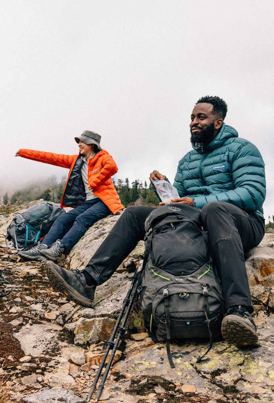
The team consists of photographers Steve Ogle, 43, and Kari Medig, 43, both of Nelson, British Columbia; professional skier Chad Sayers, 38, of no fixed address; writer Alex Frankel, 46, from Sausalito, California, and me, Chris Rowat, 47, a graphic designer from Nelson, British Columbia. To reach this remote Pacific-storm-battered mountain near the Alaska-Yukon border, we flew to Whitehorse, the capital of Canada’s Yukon Territory, then take a van to a tiny gravel airstrip appropriately named Icefield Discovery, which is stunningly nestled along the shores of Kluane Lake at the edge of the St. Elias Range. The one-hour flight to the base of Mount Logan takes half of the day. The weather is clear, but the small Helio Courier can take only two of us at a time.

Seen from the air, Mount Logan towers broad and massive above all its neighbors like an Arctic version of Australia’s Ayers Rock. Everyone I speak with who has done this route tells me to expect debilitating cold, fatigue, any number of altitude-related illnesses, and really bad storms. I am used to glacier travel and navigating avalanche terrain, including ski touring on Ellesmere Island in the high-arctic and the 75-mile (120-km) Bugaboos to Rogers Pass ski traverse just out my back door in British Columbia.
This trip is on a different level. Mount Logan has a reputation. It can be as deadly as any Himalayan peak. Only half who try actually reach the summit. In 2005, three climbers from Vancouver’s North Shore Search & Rescue barely survived when they lost their tent in a vicious storm at 18,000 feet. One of them lost all his fingers to frostbite. Four days after their rescue, an avalanche took the life of a climber on a different route. This year, the mountain had a surprise that no one foresaw. It happened while we slept soundly during our first night at Camp 1 at 10,700 feet.
Shake, Rattle and Blow
In the early morning hours of May 1, 2017, two magnitude 6.2 earthquakes hit southeast Alaska and much of the Yukon. The epicenter is only 150 miles southeast of Mount Logan. Strangely, we don’t feel a thing. We see a few serac falls that morning, but it is not until concerned friends send us messages on our InReach, our satellite communication device, that we connect the two events.
The King’s Trench is a long, straight glacier-filled valley that provides a relatively easy approach to the upper reaches of the mountain. Camp 1 is about halfway up this long valley. Camp 2 is at 13,500 feet, at the scenic King’s Col. We will probably have 4 camps in total. After the earthquake incident, we shuttle food and fuel up to Camp 2, then return to Camp 1 to sleep. The next day our attempt to move camp is thwarted by strengthening winds and failing visibility. Overnight, the wind really picks up and by morning we are hit hard. Despite our solid anchors, gusts start bending our tents in an alarming way. From the “safety” of my sleeping bag, I watch the tent walls shake and flex. Suddenly, from the other tent, and through the roar of the storm Steve yells his battle cry: “Guys, everybody out!” We crawl out into the gale and start to shovel frantically, building higher snow walls and adding extra guy-lines, all the while struggling not to be blown over ourselves. I look up from shoveling and the tent is gone. It reappears a moment later when the wind drops momentarily and the wall of driving snow eases. I’m scared the tent will blow away, and I dig faster.

Once back inside, Alex and I sit upright in our warmest clothes with our backs against the tent wall. We feel like we’re holding up a sail. I’m tense and not having fun. Kari is more relaxed. He’s experienced storms like this before, specifically during a 30-day ski traverse on an obscure Patagonian icecap where storms battered them almost every day. We get word via the InReach that there is a solo climber on the more exposed east ridge of the mountain.* We are in a valley and fairly low on the mountain. She is higher, in technical terrain. I shudder at the thought of what she must be going through. The storm rages on. My stomach is in a knot. Persistent low-level worries permeate me: What lies ahead? Will I be strong enough? Will another storm strike higher up? There’s too much time to think when you’re trapped in a tent by bad weather. Click here to view the storm captured by Alex Frankel.

The following morning the storm fades away, and like a migraine headache finally ending, the relief is palpable. We emerge from the half-buried tents and survey the damage. My tent lists to one side, it’s poles permanently bent. We dig out the cooking tarp and recover our pots, stoves, and fuel cans. The sky is blue again, and my mood lifts. Everyone is eager to advance to Camp 2 at King’s Col.
It’s a long, slow, tiring climb. The five of us are roped up as a group. The terrain is not challenging, and while the rope slows us down, there’s an unspoken agreement that we’ll play it safe today.


Above Camp 2, the middle section of the route becomes more complicated with looming seracs and big open crevasses that could swallow a bus. It’s a grueling effort to take a load of food and fuel up to Camp 3.


Feeling not up to par, I’m glad when Steve breaks trail up the 200-foot boot pack above Camp 2 and grateful when Kari takes the lead through the crevasses. Back home, this 2500-foot climb would take 2.5 hours. Up here it takes us more than double that. We reach camp late in the afternoon. The view is breathtaking. In the foreground stands King’s Peak, and in the vista beyond and below us are hundreds of little mountains poking out from a sea of ice. Mount St. Elias, almost as massive as Mount Logan, glares at us from the distance. A more technical mountain, and almost as high, it looks like a sibling of Mount Logan.
We bury the food and fuel, mark it with bamboo wands, and start a fun ski back down to Camp 2. Chad cuts some nice fast turns for Steve and Kari’s cameras. Back at the tents, Chad is unusually quiet. He noticeably limps and confides that he has tweaked his knee. The next morning it is worse, and reality sets in. We discuss options in hushed whispers. Trips like this can take 3 or 4 weeks. If he can’t continue, he’ll have to stay here in his tent for at least a week while we go up. This also means Steve would join us in our already cramped second tent. Fortunately, mixed weather moves in and for the next two days we stay put while Chad channels every healing method he can think of.


Sorry, Out of Gas
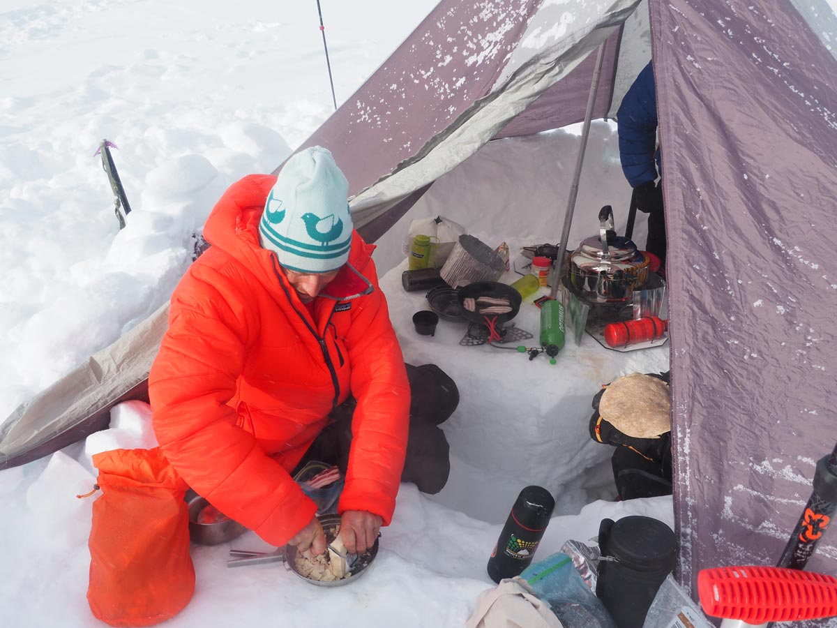
It’s 6 a.m. on summit day. I’m thinking, “Only two more ‘up’ days before we’re off this mountain.” I am tired. We’ve been struggling to boil water for an hour. Things are happening really slowly on yet another morning of bone-chilling -30°F cold. Everyone is fiddling with their boots with one of two futile hopes: putting them on now so their feet will warm up in the boots or waiting until the last possible moment to not freeze their toes more. All of us are worried about our toes. They’ll be warm in an hour, but right now they are frighteningly cold. It is little solace to know that if I can feel my toes, they’re fine.

From our final plateau camp it’s 5 miles (8 km) to the summit. We want to summit and be back in our tents in one day, so we take minimal gear: food, water, extra clothing, rope. The morning is calm and clear. Our spirits are high as we depart. A few hours later, the wind picks up and loose snow scours along the ground. There’s little discussion. It’s windy and cold, but the weather seems to be holding. We keep trudging, negotiating small crevasse fields along the way. Turning a bend, the true summit comes into view. The map says it is only one mile away. It feels much farther. I am slowing down. I seriously doubt I have enough energy to reach the summit. I untie from the rope and go at my own slow pace. Every few minutes, I stop to rest. It’s 3 p.m. and I realize I haven’t eaten much all day. The pace has left me feeling like a jellyfish. Finally, we reach the base of the final summit pyramid, where the slope steepens.
We stop to swap our skis for crampons, and the guys dig a shallow hole to get out of the wind. I’m unable to help. I have nothing left. Resigned, I look up at the peak and tell the guys, “This isn’t my day. You guys go on without me. I’ll stay here.” They are stunned and hesitant to leave me alone. Alex volunteers to stay. I’m shivering cold. The two of us huddle together under a sleeping bag to keep warm. For the first time on this trip it starts to dawn on me how far from help we really are. Even our camp seems an impossibly long way away.

The other three head off quickly for the summit, hoping to return before we get too cold. I’m grateful for Alex’s company. I don’t know how I would have coped sitting here alone for the next hour or two. As well as being out of energy, I’m emotionally drained. I can’t believe he’s given up his summit chance to stay with me. What must he be thinking? We joke a bit, but mostly I’m just quiet and try to stay warm. I feel the cold fighting to get in. I wiggle my toes in my boots. If a helicopter showed up right now, I’d jump in. I’m tired of being cold. I’m tired of the struggle. I’m done with this mountain. I tell myself, “As long as one of us makes it to the top, we’ve had a successful trip.” Geez, this isn’t Everest.
We hear a yell from above and see three figures up on the peak’s ridge. Twenty minutes later they are back. The round trip took only an hour. It’s great to see them, but I can’t help feeling a bit jealous. Kari urges us to go. “You’ll regret it if you don’t. You can do it!” His encouraging words and the rest revive me. Alex nods and we strap on our crampons, grab our ice axes, and start up. Slowly yet steadily we advance. We take 20 steps, then lean on our axes, doubled over, waiting for our bodies to stop screaming at us. And then we repeat, again and again.
Through half iced-up goggles I follow the faint pinpricks of our friend’s crampons from an hour ago. I look up and think I don’t have enough energy. A narrow ridge looms maybe 100 feet higher. I hear a grunt behind me and I’m shocked to see Alex up to his waist in a narrow crack in the snow. He pulls himself out easily. Down to my right I see the rest of the team far below in their snow hole, waiting for us. I know there are incredible views to either side of me, but they will have to wait. I’m too tired to clean my goggles, so I strain to see through the bottom corner that is still clear. I follow the crampon marks, feel the lactic acid build up that brings me to a gasping stop. I count the breaths, start again, count 10 steps, fade again. I rub in vain at my icy goggles with the back of my glove. Ten more steps. Rest. Repeat. And then the slope suddenly flattens out. There’s no more up. I collapse on the narrow summit and look around. The physical and emotional relief is pure joy. The wind even seems to ease off, and we enjoy a few minutes of happy relaxation. The view is amazing. The world is far below, like looking out the window of a passenger jet. Mountains extend to all horizons. For a moment I think the mountains are poking through a cloud layer, but it’s just the endless icecap. To my right is the friendly-looking expanse of the summit plateau, with its five or six gentle sub-peaks poking out. To my left, I peer down the steep south face as it plunges 11,000 feet to the glaciers below. There is no summit cairn. No prayer flags. It’s nice to be up here so alone. We goof around for a few pictures. I do the cliché raised-ice-axe pose. If there is ever a time I can legitimately do it, it is now. I can’t believe I pulled it together. My face mask hides a big smile. We soak in the view for a few more minutes before leaving this remarkable spot.


Returning to our plateau camp is harder than anticipated. Skiing down ice-hard snow on our tired legs makes even these mellow slopes very challenging. With our heads down, and each in our own world of fatigue, we are soon stretched out across the plateau like cows returning to the barn at dusk.
Alex has fallen far behind, moving slowly. I wait for him. It’s the least I can do. The evening is calm and clear. We feel safe, so we take our time. When we finally reach the tents, it’s 6 p.m. The return trip has taken 12 hours. The team is back together, exhausted but happy at reaching the top. We hug and high-five each other. The weather has co-operated. In a daze, I look out across the plateau and the sea of peaks beyond. A jet flies overhead, so close I can almost touch it, and I think about the passengers and chuckle at our differing situations. What are they having for dinner? With the last of our energy we make some soup and collapse into our puffy sleeping bags. What a surreal experience we are enjoying.
Two weeks up, two days down
It’s a quiet Sunday morning at the plateau camp (Camp 4) after our long summit day. The weather is fine and nobody hurries to do anything. Maybe we can rest, eat, rehydrate and just do nothing today. We don’t seem to care that we don’t have much fuel left. We chat between the tents. Steve would be happy to stay put for the day. I’m concerned about the weather changing and check the InReach for the latest forecast from my wife. The forecast seems pretty good for the next two days but then it craps out. Someone has the bright idea to call our pilot, Tom. He settles things quickly: “Glad you made it boys. We’re backed up down here so I’m doing flights to King’s Trench all day tomorrow, then other destinations on Tuesday. So if you can be at the airstrip tomorrow we can fly you out.”
Decision made! We are suddenly motivated to get the hell off the mountain. I can already taste my first beer. We slowly break camp and wearily shoulder our packs. There is one more climb to get off the summit plateau—a final kick in the teeth. We head out, toes slowly rewarming with the movement. We have 1000 feet to climb to get back up to Prospector Col. It’s a brutal grind. After that we know it will be all downhill, and that delicious thought drives our tired legs forward. Nevertheless, it’s a cold, sunny day, and a gentle wind picks up. The five of us try to stick together, but our individual rest stops result in a zombie-like pace. As we approach the col, the wind strengthens. Soon our climb is a fight. The wind is beating on us like a horde of angry children. We put our heads down and push through the onslaught. Every bit of insulated clothing is on. Leaning on my poles to catch my breath, I see Steve and Alex doing the same below me. Above me, through the driving ground blizzard, I can barely see Kari and Chad. It’s bloody cold. We have to get out of here.


Soon we are at the pass. The wind tears through this narrow, rocky notch. The visibility sucks and my hands quickly freeze as I fiddle with my boots and skins to change over to downhill ski mode. I clutch my overmitts desperately, like they’re a wad of 100-dollar bills. Losing them here is not an option. It’s at this very spot that the three Canadian climbers nearly died in a freak storm. The five of us are desperate to get down. After some yells and gestures, Chad leads with the confidence that comes from years of extreme skiing. The snow is wind-blasted and hard. I’m not a great skier and it takes all my energy to keep from falling in these conditions. Thank god it’s a mellow slope. We quickly drop 1000 feet and the wind eases. We pass a Spanish team heading up on snowshoes! We descend another 1,000 feet and we enter an entirely different world. The sun comes out. Under my face mask, I smile once again.


* On May 4, a helicopter rescued Natalia Martinez from the east ridge. The earthquake set off avalanches around her, caused seracs to collapse, and opened new crevasses. The storm nearly destroyed her tent.
Leave a comment